Environment
General
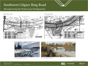
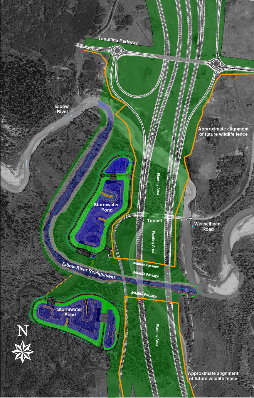
Elbow River Crossing
Elbow River Realignment
Wetlands
Wildlife
General
1. When was the environmental impact assessment done for the SWCRR?
- An updated environmental assessment was completed by AMEC Environment and Infrastructure for Alberta Transportation in December 2014, prior to the award of the construction contract
- The assessment identified potential environmental impacts and recommended mitigation measures
- The mitigation measures in the contract with Mountain View Partners were developed from the recommendations in the assessment
- Further extensive reviews and assessments have been conducted by qualified professionals to evaluate other specific environmental contexts, including wetlands
2. How does KGL protect the environment?
- KGL has a qualified environmental team that oversees all aspects of construction work
- This team is supported by third-party environmental consultants engaged by both KGL and Alberta Transportation
- The SWCRR site is subject to periodic inspections by authorities from regulatory bodies, including Alberta Environment and Parks (AEP) and Fisheries and Oceans Canada
- KGL has developed an ISO 14001 certified Environmental Management System and an Environmental and Construction Operations Plan (ECO Plan) to guide its approach to environmental matters
- The ECO Plan is audited twice a year by internal and external experts to ensure adequacy and compliance
- All work is being performed following municipal, provincial and federal requirements
- KGL has obtained (or will obtain) all required regulatory authorizations and permits to conduct its work, some of which include restrictions, requirements and reporting obligations designed to further enhance KGL’s efforts to protect the environment
- A summary of some of KGL’s environmental approaches is available here
3. What type of landscaping is planned along the completed SWCRR?
- Areas disturbed by construction will be topsoiled and seeded with native grass mixtures
- The exceptions are the river valleys, which will be planted with trees and shrubs and seeded with native grass mixtures
- The revegetation plan for the river valleys was developed during the environmental assessment and expanded upon during the design phase
Elbow River Crossing
1. What type of crossing is being built across the Elbow River valley?
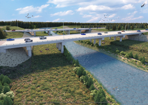
- The crossing consists of embankments approaching three multi-span bridges
- This design strikes a balance between safety, operations, environmental impacts, and cost
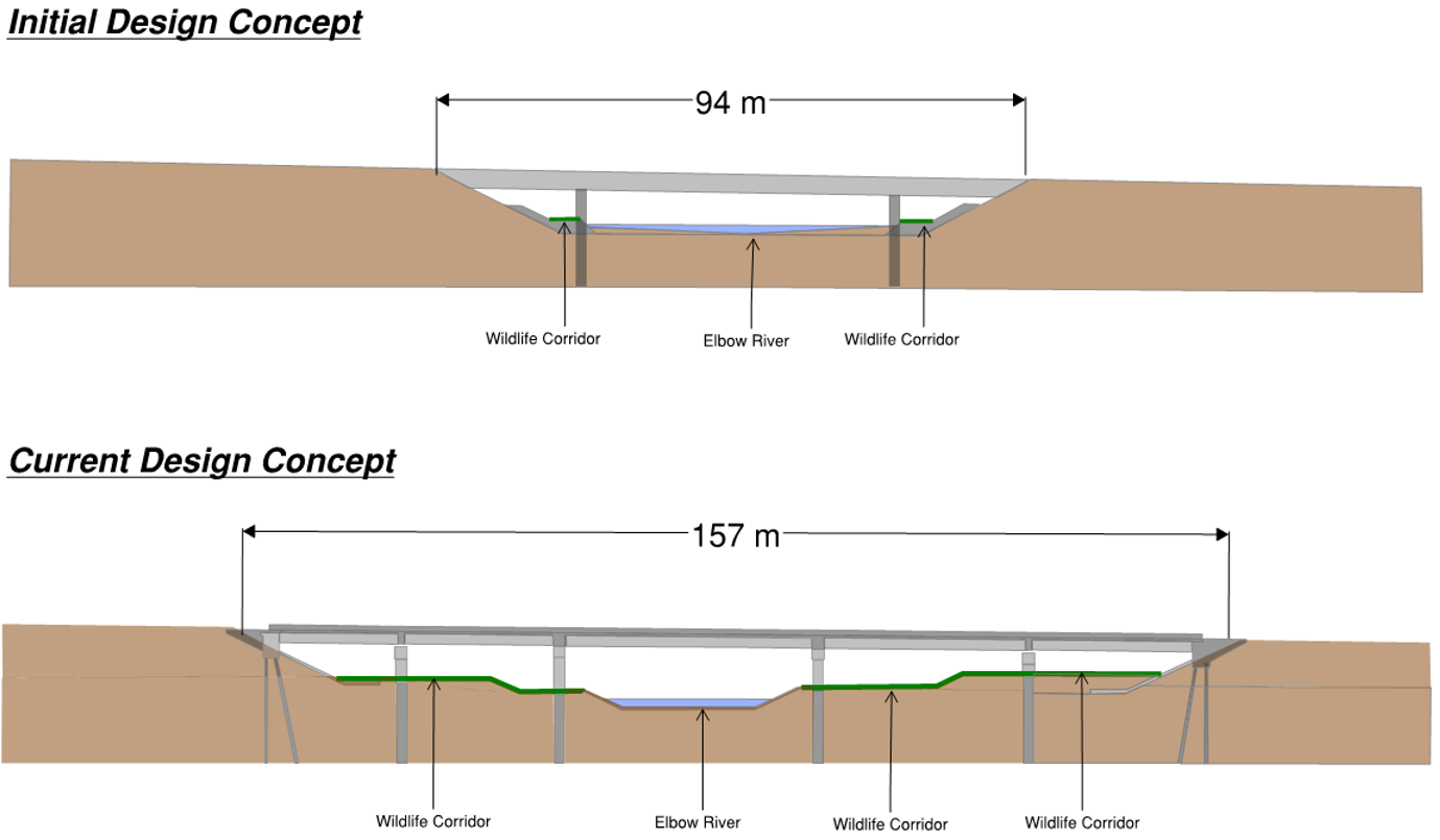
2. How long are the bridges across the Elbow River?
- The three bridges are each 157 metres long with five spans
- The bridges were redesigned in 2014 to incorporate public feedback, environmental recommendations and information from the 2013 flood
- The result was a lengthening of the bridges to 157 metres from 94 metres
3. Why not build longer bridges spanning the entire Elbow River valley?
- Alberta Transportation previously considered a number of bridge options, including structures spanning the entire valley
- The current design was selected because:
- A longer bridge is prone to icing, which would compromise the safety of the travelling public
- A longer bridge affects deck drainage and could result in safety issues during rain or snow events
- These drainage issues could impact water quality if salts, contaminants or sediments directly enter the river before being filtered by the stormwater ponds
- Each longer bridge would cost hundreds of millions of dollars more to build and the traffic requirements for this section of road require three bridges
4. Is there a risk that the embanked portion of the crossing could fail during a flood event?
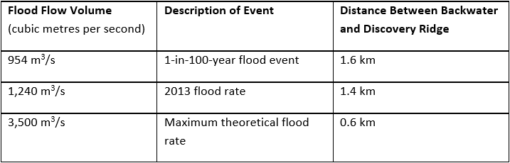
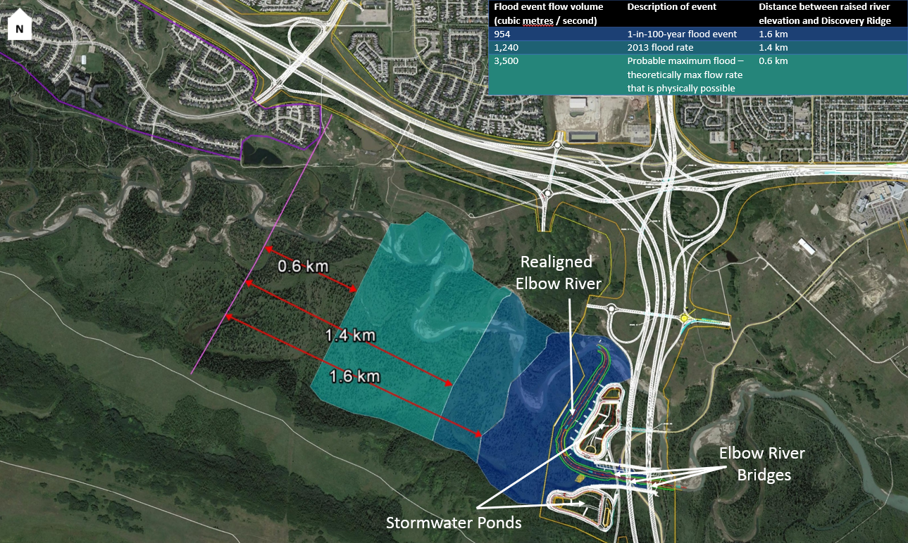
- The embankment is stable up to an extreme flood flow rate of 3,500 cubic metres per second (m3/s)
- This represents the probable maximum flood (the theoretical maximum flow rate that is physically possible), which is more than double the 2013 flood rate of 1,240 m3/s
5. Will the crossing cause flooding in Discovery Ridge?
- No, in no case does the community of Discovery Ridge receive a backwater flooding effect due to the current crossing design
- The crossing design can accommodate significant flooding events such as the 2013 flood
- The Elbow River bridges were redesigned in 2014 to increase the length to 157 metres
- This redesign provided a wider and higher waterway opening than the upstream Elbow River bridge along Highway 8 and the Weaselhead Road bridge – both withstood the 2013 flood
- During a flood, the backwater effect has been calculated in relation to the community of Discovery Ridge:
- The above findings for the hydraulic capacity of the Elbow River crossing have been verified by three independent professional engineering firms
- The design complies with all relevant federal and provincial legislation
- Additional resources:
6. Will the crossing cause flooding in communities downstream?
- No, the City of Calgary commissioned the Klohn-Crippen Berger (KCB) report, which confirmed that the crossing would pose no increased risk to Calgary’s communities upstream or downstream of the Elbow River crossing
- The study confirmed that there is no increased risk of failure of the Glenmore Dam as a result of the construction of the crossing
7. What are the flow capacities of the bridge openings?
- Provincial criteria require that flow capacity of the bridge channel is greater than the 100-year flood flow (954 m3/s)
- The bridges have sufficient capacity to convey a 100-year flood flow with at least two metres of clearance between floodwaters and the bridge decks
8. Will the bridge openings be blocked by debris during a flood?
- It is unlikely that flood debris, such as dislodged trees, will cause a blockage due to the space between the bridge piers
9. Will the design of the bridges result in higher discharge velocities downstream?
- No, the footprint of the crossing is too small in comparison to the overall catchment area and the total floodplain storage of the Elbow River
10. How will the bridge crossing affect the Elbow River in Weaselhead Park?
- The Elbow River will continue to meander naturally both upstream and downstream of the crossing and will not be confined to a defined channel
- The Province and City have agreed to monitor the Elbow River annually for five years following project completion to assess any impacts to the riverbanks or riparian health
11. Does the City of Calgary have concerns regarding the design of the Elbow River crossing?
- No, Alberta Transportation consulted with the City during the planning and design stages of the project, and discussions are ongoing during construction
- The City’s input was considered in the development of technical requirements for the bridges over the Elbow River
- During the planning stage, the City secured a third-party consultant to provide a professional engineering opinion regarding the safety of the Glenmore Dam
- The KCB study was completed in fall 2015 and concluded:
- The revised crossing design does not present additional risk to the Glenmore Reservoir, causeway, or dam
- The revised design provides improvements over the original design in terms of the water capacity of the bridge and channel erosion
- A morphology analysis concluded that, like the rest of the Elbow River upstream of the reservoir, the river at the crossing experiences changes in shape and path over time and monitoring will be conducted to identify possible impacts from the project
- In addition, the current detailed design of the bridge crossings and river realignment was shared with the City and a review concluded that the design:
- Resulted in further increases to the hydraulic capacity of the crossing
- Provided greater detail on fish habitat, channel stability, and erosion control features
- Would not negatively impact the Glenmore Reservoir during flood events
- A five year monitoring program between Alberta Transportation and the City started in 2017, prior to the channel realignment work to ensure a baseline for a before/after comparison
- Additional resource:
12. Does the crossing impact the floodplain?
- Natural processes will not be adversely impacted as the floodplain will continue to be activated, both upstream and downstream, during flood events
- In order to minimize environmental impacts, the cross section and geometry are being maintained to keep the overall channel slope and related stream characteristics unchanged
- The crossings do not add any increased flooding impacts, as verified by three independent professional engineering studies
13. Will runoff from the crossing drain to the Elbow River?
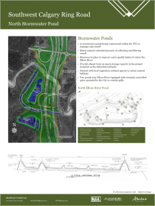
- No, two stormwater ponds are being constructed at either end of the bridges to contain runoff
- The ponds will mimic the natural watershed process of collecting and holding runoff from the road before gradually releasing it to the river
- Alberta Transportation worked with the City of Calgary to establish standards that ensure the quality of water that will re-enter the Elbow River
- These standards will go above and beyond those set by AEP (AEP is 85 per cent of sediment removed)
14. What happens to the water storage capacity of the wetlands removed by construction of the Elbow River crossing?
- The stormwater ponds at both ends of the bridges are designed to provide more water storage volume than was previously provided by the impacted wetlands
15. What happens if there is a release of pollutants from vehicles using the bridge?
- The stormwater ponds will be equipped with automated gates that can be immediately closed from a remote location, which will provide additional protection in the event of a spill
16. Can the stormwater ponds be washed-out during a flood?
- The containment dykes surrounding the stormwater ponds will be high enough to prevent overtopping and wash-out up to a 1:200 year flood event (approximately 1,240 m3/s)
- The erosion protection around the ponds is designed to accommodate changes to the river channel
17. How is water quality being protected during construction?
- Best management practices are being followed to ensure effective erosion and sediment control
- This includes the use of vegetation buffers, silt fencing, temporary seeding or protection blankets, and runoff diversions
- Regular inspections of these measures are carried out by KGL’s environmental team and expert third-party consultants
- No equipment is permitted to enter waterways
18. Was wildlife considered in the design of the crossing?
- Yes, the environmental assessment was completed and the design was developed to minimize potential impacts on wildlife, fish and habitat
- Field studies were undertaken during the planning stage to characterize existing conditions for wildlife and habitat, and to document wildlife movements
19. How will wildlife pass under the bridges?
- Each Elbow River bridge provides three wildlife corridors for passage of small and large animals
- Each corridor ranges between 15 and 30 metres in width
- Native grasses and shrubs will be planted along these passages and adjacent to the bridge structures to provide cover for wildlife
- Wildlife passages are designed to maintain connectivity between habitats and wildlife populations, and to increase motorist safety
- To ensure public and wildlife safety, fencing will be installed that will direct wildlife towards these passages
- Recreational pathways will not be constructed through the bridge crossings to minimize interactions between humans and wildlife
20. What precautions are taken during the construction of the crossing to protect wildlife?
- Environmentally sensitive areas are delineated with flagging and /or fencing prior to adjacent work
- Per legislative requirements, vegetation clearing is timed to avoid the breeding season for migratory and non-migratory birds
- Activity is minimized during winter months to avoid displacing wildlife
- Construction activities don’t take place overnight between late December and April to allow free animal movement
- Wildlife sweeps are conducted prior to starting construction in an area
- A biologist monitors the project to ensure wildlife movement is not impeded during construction of the Elbow River and Fish Creek crossings
21. Is the work subject to any environmental oversight and control?
- The SWCRR is a provincial project and complies with Alberta Transportation standards
- The project also adheres to all relevant federal and provincial regulatory requirements, including regulations from AEP and Fisheries and Oceans Canada
- Alberta Transportation consulted with the City during the planning of the Elbow River crossing and their input was considered in the design
- Numerous authorizations and permits have been acquired or will been obtained prior to completing the required work
Elbow River Realignment
1. What is the Elbow River realignment?
- River realignment creates a new, permanent water channel
- This allows for construction of the crossing, while minimizing impact to fish and habitat by providing a bioengineered channel comparable to the river’s original path
- An equivalent process and timeline are being followed for the realignment of Fish Creek
2. Is river realignment a common practice?
- Yes, river realignment is a common engineering process and there are a number of examples in Alberta
- This includes the realignment of the Sheep River in the Town of Okotoks for the 32 Street bridge crossing
- The Okotoks crossing included the permanent diversion of the Sheep River into a newly constructed channel approximately 700 metres in length
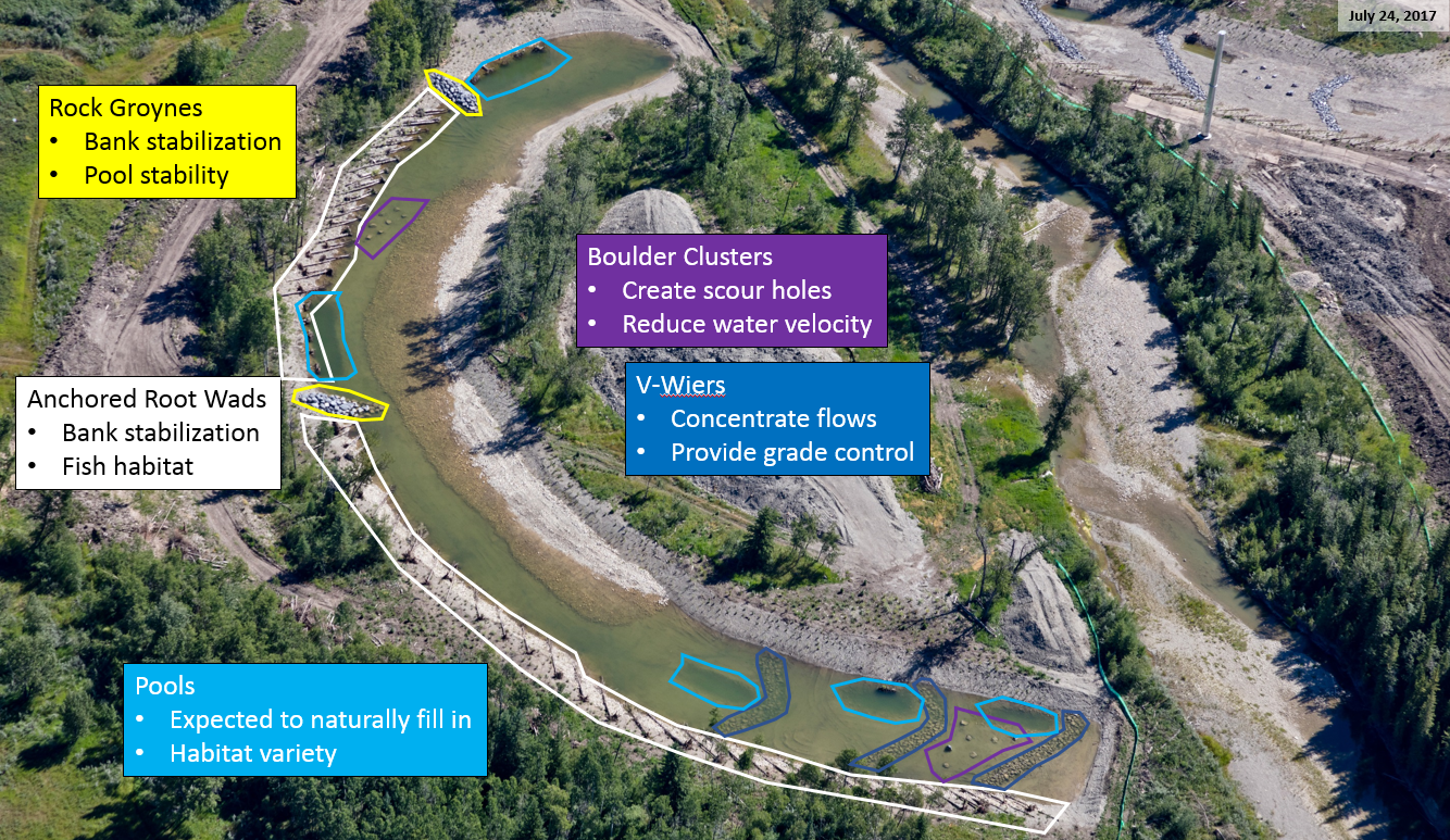
3. What is bioengineering?
- Bioengineering is a technique used when realigning waterways
- It integrates living trees, shrubs and grasses together with tree roots, woody debris and rocks to increase the strength and structure of the streambank, while blending into the natural environment and providing habitat
4. What was the timeline for the realignment of the Elbow River?
- In the spring of 2017, a new permanent channel was excavated and bioengineered so the width, slope, depth, velocity and other ecological conditions of the river remained the same after the realignment
- Root structures, willow saplings and other native vegetation was established along the new river channel and was given 10 to 12 months to grow
- The Elbow River was then diverted in April 2018
- All work, including the opening of the new channel, was timed to minimize the impact to fish and other wildlife, as required by AEP and Fisheries and Oceans Canada
5. Won’t the river find its own path?
- The river will continue to meander upstream and downstream of the crossing, but the bioengineering work will create stable banks along the course of the river realignment
6. What are the impacts on fish and fish habitat?
- The realignment is designed and engineered to enhance the quality of the river habitat for fish and other aquatic and wetland species
- The switch from the existing river to the new channel took place outside of the restricted activity period for the Elbow River
- A fish rescue was carried out before and after the river was diverted to relocate fish trapped in the old channel
- The following example provides an aerial view of the work for the Fish Creek realignment
7. How was water diverted to the new channel?
- The new channel was opened in April 2018.
- The plugs at either end of the new channel were excavated, opening the channel and redistributing the water
- The old channel was plugged at the upstream end with material from the Elbow River valley
- The water drained out of the old channel naturally and was then pumped out of any residual pools
- Once the channel was completely drained, the downstream end was plugged
8. What permits are required for the river realignment?
- A Water Act approval was issued by AEP and a Fisheries Act authorization was issued by Fisheries and Oceans Canada to complete the work
- This was to ensure that any work that could impact fish habitat was done according to federal standards
9. How will the old channel be reclaimed?
- The old channel will be filled in and an embankment constructed to the new highway elevation
- Fill material is required to be from the Elbow River valley, so all of the fill will be native material from the new channel’s excavation and material from the banks on either side of the valley
- Once the SWCRR is complete, there will be minimal indication of the previous channel
Wetlands
1. What wetlands are you impacting?
- There are a number of natural and man-made wetlands in the Transportation Utility Corridor (TUC) that will be impacted by the construction of the SWCRR
2. What approvals are required to impact wetlands?
- Permits under the Water Act are authorized by AEP
3. Why are you disturbing these wetlands?
- Wherever possible, wetlands in the TUC are being avoided
- However, due to the restricted space in the TUC, the ability to build around wetlands is limited
4. How are you compensating for wetland disturbance?
- All wetlands disturbed by the project will be compensated using an approach as agreed with regulatory agencies
- To address the areas where wetlands cannot be salvaged, replacement wetlands will be created in Alberta (Ducks Unlimited Canada)
- A compensation plan was developed to achieve “no-net-loss” of regional wetland function in accordance with the requirements and objectives of the Water Act and the Federal Policy on Wetland Conservation in Canada
- Stormwater ponds along the project corridor will also be planted with wetlands vegetation
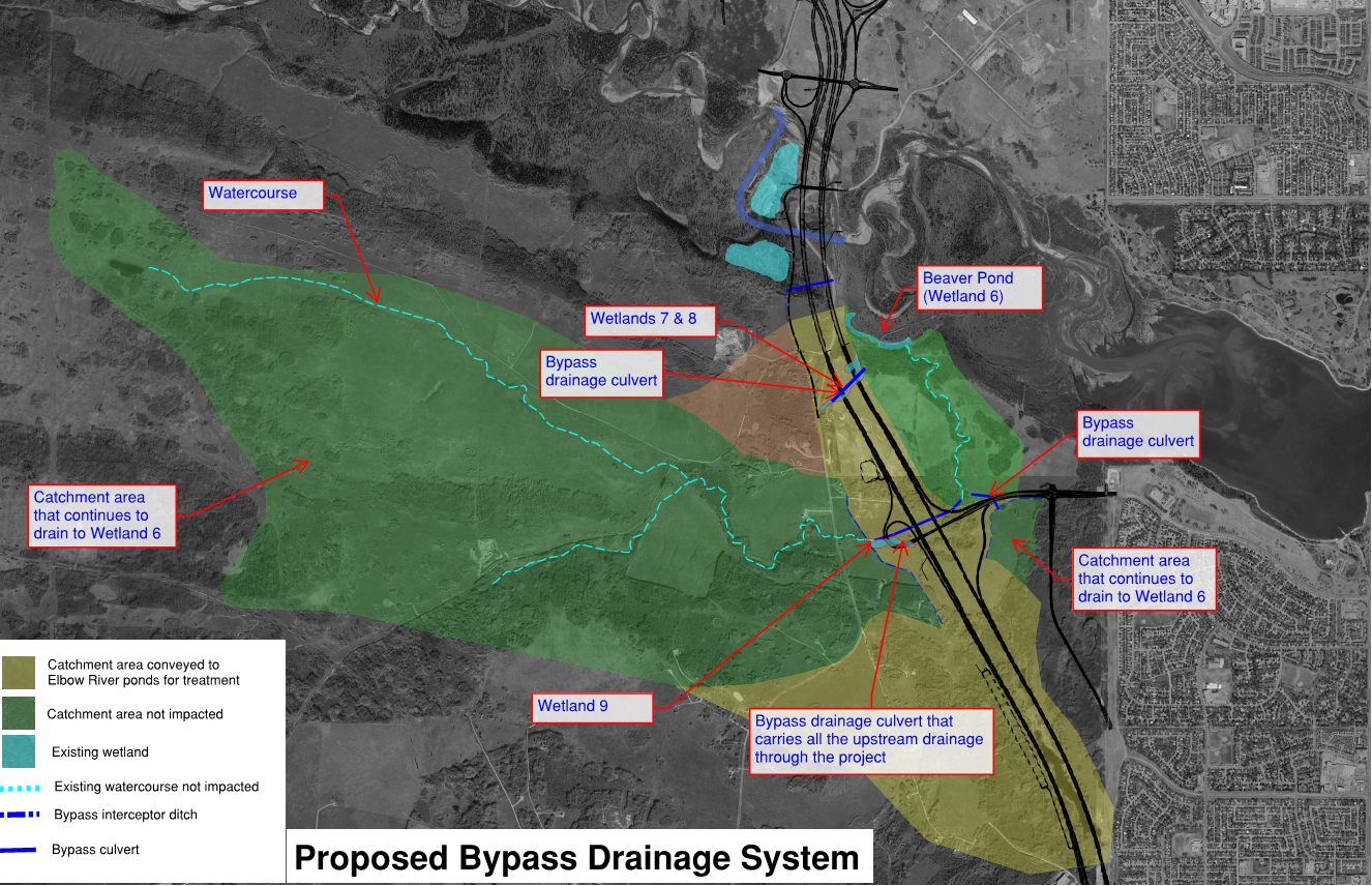
5. What are the impacts on the City of Calgary’s Wetland 6 (Beaver Pond) adjacent to the project boundary?
- KGL’s design avoids having any impact on Wetland 6
- During construction, the wetted surface will be protected by a buffer area and sediment fence
- The quality and quantity of water in Wetland 6 will be monitored twice a year until 2025
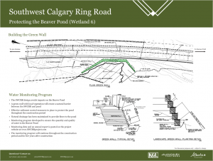
6. How will water continue to reach the Wetland 6?
- Culverts and stormwater lines have been installed in the drainage area to ensure that water flows continue to reach Wetland 6
- These measures were designed by consultant water resource engineers
- Environmental specialists and inspectors from AEP have reviewed the works to ensure connectivity
7. How many stormwater ponds are being constructed along the SWCRR?
- 21 stormwater ponds are being constructed along the length of the project corridor, providing almost twice as much water storage capacity as disturbed wetlands
- The stormwater ponds mimic the natural watershed process of collecting and treating runoff, and will be planted with native vegetation
8. What was the impact of the decision by the Alberta Environmental Appeals Board?
- The road design underwent minor modifications to completely avoid Wetland 6
- The previous design disturbed five per cent of Wetland 6 above the wetted perimeter
- KGL worked with AEP to reassess impacts on 24 wetlands based on the recent wetlands policy
- The quality and quantity of water in Wetland 6 will be monitored twice a year until 2025
8. Where can I find more information about the Alberta Environmental Appeals Board?
- Further information is available here
Wildlife
1. How are you protecting wildlife during construction?
- Sweeps of the TUC are carried out by third-party consultant biologists to identify wildlife and habitat
- Where required, wildlife buffer zones are established until such time that animals move to another location
- KGL works closely with AEP to ensure that wildlife is being managed in accordance with requirements
- Wildlife sightings are reported by field staff using Critter Cards
- Wildlife crossings are being preserved at key locations
- Per legislative requirements, vegetation clearing is timed to avoid the breeding season for migratory and non-migratory birds
- In instances where clearing takes place outside of the breeding season, amphibian and bird sweeps are carried out by third-party consultant biologists
- Field staff inspect areas for wildlife habitation prior to carrying out maintenance operations, such as grass mowing
- KGL’s consultants maintain a permit to relocate amphibians in case they are located in a breeding pond that will be disturbed by construction